

Blog I Day 2 I Cycling Through British Columbia, Canada: From the Pacific to the Semi-Desert
July 2024 I Vancouver International Airport → Mission, (Sun Valley RV Park)
All contents © COPYRIGHT patrizia.co 2008 -2026. ALL RIGHTS RESERVED. Website made and designed by Patrizia
The sun is already high, and the mild air promises an ideal ride. After meeting my travel companion, who has just landed from Alberta, we take the necessary time for her to assemble her bike on her own, straight out of the large cardboard bike box. It’s a simple yet symbolic moment: bolts tightened, bags secured, final checks. From here on, the road is ours.
We leave the airport following Miller Road, passing mainly through airport-related areas and infrastructure, with the small historic community of Burkeville along the way. It’s the perfect stretch to warm up the legs, a mix of urban scenery and early hints of nature.
We continue along the Sea Island Way bike path, safe and smooth, until reaching No. 3 Road. Here we join the cycle path that runs beneath the SkyTrain (Canada Line) a protected, flat section that allows us to cross the area safely and connect to the River Rock Casino district.
From the River Rock Casino, the route follows the Fraser River, alternating dedicated bike paths with quiet, low-traffic roads. This section offers the first true river landscapes: green banks, moored boats, and the slow movement of the water perfect for settling into the rhythm of the ride.
Continuing along the river, we cross the Queensborough Bridge. From here, the BC Parkway leads us directly into New Westminster, connecting to the Waterfront Esplanade, a paved, multi-use path ideal for cyclists and pedestrians alike.
The route follows the waterfront along Quayside Drive, crossing the Waterfront Esplanade and Park, one of the most pleasant sections of the city. We ride just meters from the water as the Fraser River flows slowly and quietly beside us. Repurposed industrial buildings, historic docks, and boardwalks tell the story of New Westminster’s river-based past, now transformed into a lively and welcoming urban space.
We then reach Columbia Street, the city’s historic main road. New Westminster was the first capital of British Columbia before that status moved to Victoria on Vancouver Island in 1868. Along the way, the massive structure of the Pattullo Bridge dominates the urban skyline.
From here we merge onto the Central Valley Greenway, a continuous, well-marked cycle route that takes us to the Brunette River, then onward toward Fraser Mills, skirting the Fraser River through South Coquitlam.
Gradually leaving the urban environment behind, we enter ƛ̓éxətəm Regional Park (formerly Minnekhada Regional Park), along the Coquitlam River, within the traditional territory of the Kwikwetlem First Nation. Here, asphalt gives way to gravel paths, gentle rolling terrain, wetlands, and dense forest. The pace slows, the view opens up. Silence is broken only by birdsong and the sound of flowing water.
This park is a rich wildlife habitat, and the sense of being fully immersed in nature is constant. That feeling is confirmed by a sudden encounter with a black bear, spotted at a distance among the vegetation a quiet, discreet presence that watches us briefly before disappearing into the forest.
It’s a short but intense moment, instantly restoring the proper sense of scale between us and the land we are crossing. This is a place where nature doesn’t perform it simply exists.
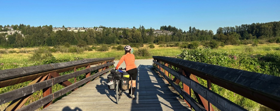
Leaving the park, the Fraser River becomes the Pitt River, which we cross on the long Pitt River Bridge, suspended above a wide, sunlit valley. Shortly after, the river resumes its original course and accompanies us toward the South Alouette neighbourhood, finally guiding us into Maple Ridge. Here the landscape opens up: orchards, cultivated fields, wide skies, and horizons that seem to stretch time itself.
The final kilometres follow Highway 7 (Lougheed Highway), still parallel to the Fraser River. We pass through Silverdale, a semi-rural area of the District of Mission, then turn onto Avenue Road toward Mission, reaching Sun Valley RV Park, where we pitch our tent surrounded by greenery.
The owner casually tells us that a mother bear and her cubs have lived there for years: “She’s part of the place. Every summer she moves around the area, but she never causes trouble.”
That night, in the darkness of the forest, their presence is clearly felt: a rustle among the trees, the calls of nocturnal birds, a light but respectful tension. We never see them, but the boundary between our space and theirs is thin and shared—an unspoken agreement between humans and wilderness.
The evening drifts by slowly, wrapped in forest silence. Our thoughts already turn to the next day: the first real climbs toward Hope and the mountain landscapes of the Cascade Mountains.
Stage of the Route
• Tour map 📍: Map
• Distance 🚴: ~88 km
• Estimated duration ⏱: ~6h 48min, including stops and breaks
• Main locations: Vancouver International Airport (YVR) → Richmond → New Westminster (Westminster Quay / Quayside Park) → Port Coquitlam → ƛ̓éxətəm Regional Park → Pitt River Bridge → South Alouette → Maple Ridge → Mission (Silverdale)
• Terrain: Paved urban roads, riverside cycle paths, mostly flat sections, gravel trails within the regional park, gentle rolling terrain approaching Mission
• Direction: Generally eastbound, following the Fraser River inland
• Region / District: Metro Vancouver → Fraser Valley Regional District
• Difficulty: Medium – easy stretches alternating with long flat sections; regional park trails may require basic off-road skills
• Points of interest: Sea Island Way, Moray Bridge, River Road Cycle Path, Westminster Quay / Quayside Park, Pattullo Bridge, Port Mann Bridge, ƛ̓éxətəm Regional Park, Pitt River Bridge, Fraser Valley landscapes
• Overnight stay: Sun Valley RV Park, Mission (Silverdale)
• Travel footage: Route stage and travel footage captured with Action Cam Insta360 X