

Blog I Day 1 I Cycling Through British Columbia, Canada: From the Pacific to the Semi-Desert
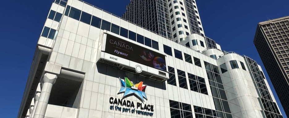
July 2024 | Canada Place → Vancouver International Airport (YVR), British Columbia, Canada
I set off from Canada Place, one of Vancouver’s most iconic locations. The great white sails of the cruise ship terminal stood out against the morning sky like ships ready to depart for Alaska. Around me, the harbor was already alive: travelers, rolling suitcases, distant voices, and the muted sound of water lapping against the docks. With the salty scent of the ocean in the air and the Coast Mountains rising in the background, the beginning of my cycling journey slowly took shape.
Pedaling along the Coal Harbour Cycle Path, a scenic and perfectly paved section of the Seaside Greenway, Vancouver revealed itself in its most successful balance: glass, steel, and nature coexisting effortlessly. The path follows the waterfront past the Vancouver Convention Centre, where contemporary architecture is mirrored in the calm waters of the harbor.
A little farther on, at Jack Poole Plaza, the large Olympic cauldron recalls the legacy of the 2010 Winter Games a powerful symbol of a city able to open itself to the world without losing its connection to the surrounding landscape.
Continuing west, the route opens onto English Bay, Vancouver’s most popular urban beach, directly facing Beach Avenue. Here, the ocean meets the city in a bright embrace: golden sand, kayaks on the water, runners and cyclists sharing the space beneath a sky often streaked with light clouds.
Nearby, still along Beach Avenue, the large bronze figures of A-maze-ing Laughter catch the eye. The fourteen sculptures, all bearing the same laughing, distorted face, seem to observe the constant flow of people, adding a surreal and ironic note to the coastal scenery.
Without circumnavigating Stanley Park, I gradually leave the waterfront behind and follow Beach Avenue toward the Burrard Bridge. Crossing it by bike feels like a true rite of passage: behind me, the downtown skyline; ahead, quieter residential neighborhoods, suspended between water and city. Once across the bridge, traffic thins, sounds soften, and the rhythm of pedaling becomes steadier.
From here I merge onto the Arbutus Greenway, a long cycling path following a former disused railway line. It is a green corridor designed for slow movement, far from major roads. Low houses, well-kept gardens, and small parks slide by on either side, while the city seems to dissolve almost without notice.
Children playing, residents out for a walk, everyday gestures accompanying the ride: it is a direct and quiet connection with local life, a natural transition from the urban environment to the journey itself.
Reaching the southern end of the trail, I follow SW Marine Drive and cross the Arthur Laing Bridge, leaving the urban fabric definitively behind. Ahead lies the area of Vancouver International Airport (YVR), a place of passage and a symbolic boundary. It is here that, the following day, I would meet my travel companion arriving from Alberta, one of Canada’s great provinces. After taking stock of the place and the route, I head back home for one last night before the true departure.
This first day, short yet intense, is a moment of transition and listening. The wind on my face, the lingering scent of the sea, and the mountains closing the horizon create a quiet anticipation of the adventures ahead. The evening is spent near the airport, hosted by friends, amid laughter and shared stories.
It is that rare feeling of being at home even when far away, on the eve of a journey that will carry us into the heart of British Columbia, across the traditional and unceded lands of the First Nations where the road is not merely a geographic line, but a continuous encounter with the land and its memory.
Pedal stroke after pedal stroke, Vancouver fades behind me. The coast, the harbor, and the urban beaches give way to a more intimate and silent route. This is the true beginning of the journey: the moment when the bicycle ceases to be an urban means of transport and becomes an instrument of exploration. Ahead, kilometers of roads, mountains, and wild landscapes. Behind, the ocean.
Where it all begins
Stage of the Route with
• Tour map 📍: Map
• Distance 🚴: ~22.8 km
• Estimated duration ⏱: ~1h 40min, including stops and breaks
• Main locations: Canada Place → Coal Harbour Cycle Path → Convention Centre → Beach Avenue → Burrard Bridge → Arbutus Greenway → SW Marine Drive → Arthur Laing Bridge → Vancouver International Airport (YVR)
• Terrain: Scenic bike paths, urban asphalt roads, waterfront stretches, bridge, and residential routes
• Direction: Mainly eastbound, following the Fraser River inland
• Region / District: Metro Vancouver
• Points of interest: Canada Place, Convention Centre, English Bay, Beach Avenue, Burrard Bridge, Arbutus Greenway, Vancouver International Airport (YVR – Sea Island, Richmond)
• Overnight stay: Richmond / Vancouver, at my place
• Travel footage: Route stage and travel footage captured with Action Cam Insta360 X