

Val Codera and Tracciolino Trail – Loop Hike from Novate Mezzola (Sondrio, Lombardy), Italy
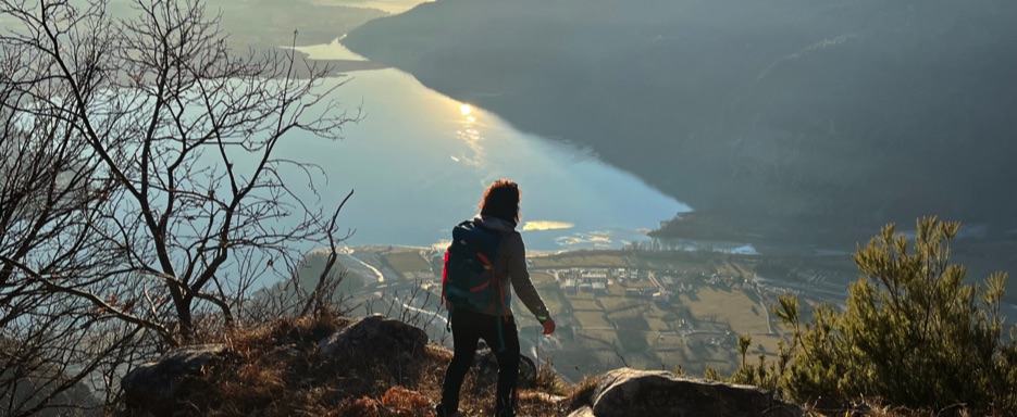
Val Codera is one of those rare places where time seems to have stood still. An authentic and unspoiled corner of Lombardy, often considered one of the finest examples of an Alpine valley preserved in its original form.
Located in the province of Sondrio, just a few kilometers from Lake Como and the Swiss border, it is a remote, roadless valley still served today only by a historic mule track. Here, nature rules, not the modern world.
Accessible only on foot (or by experienced mountain bike riders), Val Codera is home to one of the last Alpine villages reachable exclusively by hiking or helicopter, making every visit feel like a true journey back in time.
Start of the hike: from Novate Mezzola
The hike begins in Novate Mezzola, where we leave the car in one of the local parking areas. From here, we immediately take the mule track climbing steadily through the forest, with beautiful sections of stone steps. The elevation gain is noticeable right from the start: the ascent is constant and gradually opens up wider views over the valley.
Towards the heart of the valley
After passing a small chapel in a stunning panoramic position, the trail enters the valley from above, passing through the locality of Avedée. With gentle ups and downs through the woods, Val Codera slowly reveals itself. The mule track follows the winding right side of the valley, offering spectacular exposed sections above the valley floor, protected by safety railings. The sense of isolation is total.
Codera: a village frozen in time
Codera is the only permanently inhabited Alpine village not reachable by roads or cable cars. Entering the village feels almost mysterious and ghost-like: stone houses, silent alleys, and courtyards suspended in time, crossed by the Codera stream.
Val Codera takes its name from this stream, which runs through the entire valley, rises from Pizzo dei Vanni, and flows into Lake Mezzola. In the village, traces of the past are still clearly visible, including an old oratory and the parish church with its isolated bell tower.
Here we take a lunch break near the stream, sitting on the rocks with cold water flowing beside us, enjoying open views toward the horizon and, on clear days, the mountains of Switzerland.
From the village to the Tracciolino and San Giorgio Cola
Instead of returning along the same route, we leave the village by crossing a historic stone bridge, reaching the opposite side of the valley. Along the way, we cross two beautiful ancient bridges and look down onto impressive natural potholes carved into the rock. After a forested section, we reach the small settlement of Cii and reconnect with a section of the Tracciolino Trail.
While walking along the Tracciolino toward San Giorgio Cola, we meet other hikers coming from the opposite direction, who kindly share useful information about the route ahead.
The valley opens up with breathtaking views of waterfalls, sheer rock walls, and surrounding peaks. The rugged granite terrain gradually gives way to birch and chestnut forests, and the well-trodden trail runs over forest floor and fallen leaves.
At the junction for San Giorgio Cola, we leave the Tracciolino (the Val di Revelaso section is closed due to landslide risk) and descend toward Novate Mezzola along a different trail from the ascent. This long descent, steep and full of switchbacks, offers beautiful views over Lake Mezzola and the surrounding landscape before re-entering the forest and reaching the valley floor.
Return: Novate Mezzola
The loop ends right where we parked the car. The fatigue from both the ascent and the descent is rewarded by the panoramas, the deep connection with nature, and the shared experience with hiking companions—making this adventure truly unforgettable.
Val Codera is not just a hike:
It is a journey into a world where the mountains still set the rhythm of life, where the absence of roads becomes a value, and where every step brings you closer to nature and history.
📌 Trail Details – Val Codera & Tracciolino Trail
• Start & Finish 📍: Novate Mezzola (SO)
• Route type 🔁 : Loop hike
• Total distance 🥾: Approx. 14–15 km
• Elevation gain ⛰️⬆️ : Approx. 1,100 m
• Maximum altitude ⛰️: Codera ~ 825 m a.s.l. / Tracciolino ~ 950 m a.s.l.
• Average time ⏱️: 6–7 Hours, breaks included
• Difficulty 💪: E (Hiking)
• Terrain ➿ : Historic mule tracks, mountain trails, rock-cut sections, tunnels
• Waymarking: Well-marked CAI trails
• Exposure: Some exposed sections protected by railings
• Water 💧: Fountains available in Codera and along the route
• Access: On foot only (or experienced mountain biking on selected sections)
• Unique feature: Roadless valley, one of the last Alpine villages accessible only on foot or by helicopter
• Points of interest ⭐: Codera, Avedée, Cii, San Giorgio Cola, stone bridges, views over Lake Mezzola
• Route Map 📍: View Map Coming Soon
🎥 Videos & 📸 Photos from the Route
Video 1 – The Ascent to Val Codera
From the parking area in Novate Mezzola, the hike begins along the steep historic stone mule track, climbing through the forest via rocky steps and gradually opening views. This video captures the effort of the ascent and the first breathtaking panoramas as the trail enters Val Codera from above.
🎥 Video 2 – Codera Village & the Tracciolino Trail
The heart of the hike: the village of Codera, the stream flowing through it, a lunch break by the water, and the timeless atmosphere of a place where time seems to stand still. The route then continues along the Tracciolino Trail, with tunnels carved into the rock, protective railings, exposed sections, and spectacular views over the Rhaetian Alps and the valley below.
🎥 Video 3 – The Scenic Descent Back to Novate Mezzola
The final section of the loop: a long descent on the opposite side of the valley, starting with wide panoramic views over Lake Mezzola before re-entering the forest. This video follows the return toward the valley floor, concluding the hike back at the parking area.