

Torre di Segname – Cà Pipeta Hiking Loop from Gordona (Sondrio, Lombardy), Italy
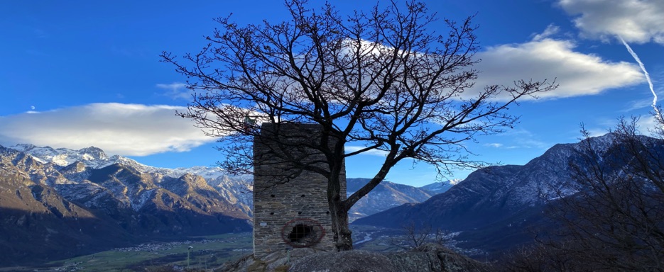
The hike to Torre di Segname takes you through the picturesque landscapes of Valchiavenna, a region rich in history and natural beauty. Starting from the village of Gordona, this route leads to the tower, an ancient watchtower dating back to the 9th–10th century, strategically built on a rocky summit.
The tower offers a glimpse into the past while providing breathtaking panoramic views of the surrounding Orobic Alps and the valley below. This circular route also crosses valleys, streams, and woodlands, making the hike a perfect blend of nature, history, and adventure.
Start: Gordona
Starting from Gordona, near the Boggio stream (Bögia) which collects the waters of Val Bodengo and its side valleys we park the car and begin the hike through quiet forests, where the trees have lost most of their leaves due to the off-season.
After crossing the bridge over the stream, we encounter several signposts pointing in different directions. We follow the trail toward Torre di Segname, Cà Pipeta, and Samolaco, taking the old mulattiera (mule track) that winds uphill through switchbacks in birch and chestnut woods.
As we continue, the trail runs high above the valley cliffs, offering scenic views, before opening onto a panoramic outlook over Gordona and the valley below, just before the final ascent to the tower.
Trails Through Forests and History
The route passes through beech and larch forests, autumn clearings, and leaf-covered paths. The seasonal landscape, with old chestnuts scattered along the trail, creates a magical and immersive atmosphere. Along the way, we encounter several signposts, but we always stay on the main path leading to the tower.
Torre di Segname
Built directly on the rock, the tower was part of a strategically positioned system of lookout towers. At its base, we find a circular gated entrance that we open to step inside. Climbing the spiral staircase to the top, we are rewarded with spectacular views: snow-dusted peaks, small villages in the valley, and the wild beauty of Valchiavenna. At the summit, the Italian flag waves in the wind, and the tower allows us to observe every detail of the landscape from above.
Encounters Along the Trail
During the hike, we are accompanied by groups of grazing goats and other animals, adding a lively and authentic touch to the experience. After leaving the tower, the goats follow us for a short stretch before heading off in another direction.
Cà Pipeta and Ancient Structures
Continuing along the loop trail, we pass abandoned mountain huts and reach Cà Pipeta (470 m), a site rich in history. Here we find the remains of a large man-made structure carved directly into the rock, consisting of eight rooms, including a stable, hayloft, kitchen, and sleeping quarters.
Atmosphere and Views
The trail offers ever-changing scenery: meadows, forests, streams, and ancient ruins, all immersed in the quiet of the mountains. On the return toward Gordona, we enjoy a spectacular sunset, with the mountains glowing in vivid colors the perfect ending to a beautiful day outdoors.
Return
The loop trail brings us back to the starting point near the Boggio stream, completing a hike that combines history, nature, and alpine scenery without overly demanding sections.
Why Choose This Hike
A moderate-difficulty excursion, ideal for a half-day outing. Perfect for those who love nature, history, and alpine views, suitable for beginner to intermediate hikers looking for an authentic walk through forests, medieval towers, and ancient mountain settlements.
📌 Trail Details
• Start & Finish 📍: Gordona, near the Boggio stream (Bögia)
• Access: Parking area near the bridge over the Boggio stream, which collects the waters of Val Bodengo and its side valleys
• Total Distance 🥾: ~5.5–6 km
• Elevation Gain ⛰️⬆️ : ~250–300 m
• Maximum Elevation: 655 m (Torre di Segname)
• Average Time ⏱️: 2.5–3 hours (round trip, breaks included)
• Difficulty 💪: Moderate – mostly easy terrain with an initial flat section, a gradual ascent toward the tower, and panoramic stretches above small cliffs; no technical equipment required
• Terrain 🛤️ : Dirt mule tracks, forest trails through beech, larch, birch, and chestnut woods, open clearings, and leaf-covered paths
• Trail Marking 📍: Clear signage with directions to Torre di Segname, Cà Pipeta, Samolaco, and local trails
• Gradient 📈: 10–20% on the steepest sections near the tower; gentle and steady at the beginning
• Map 📍: View Map – Coming Soon