

Hike to Pizzo Scalino – the Pyramid-Shaped Peak of Valmalenco (Sondrio, Lombardy, Italy)
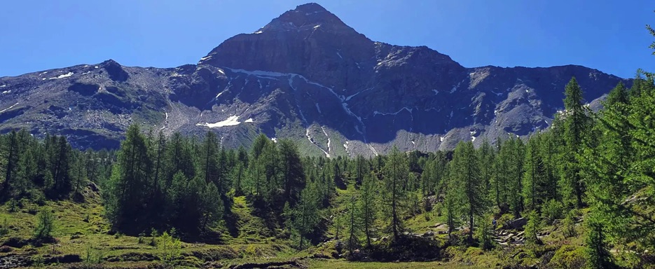
The Rhaetian Alps offer grandiose landscapes and spectacular peaks, and Pizzo Scalino, located in the heart of Valmalenco (Sondrio, Lombardy, Italy), at 3,323 m, is one of the most captivating mountains in the area.
This is a high-mountain hike, long and challenging, taking place in a breathtaking environment that includes gentle trails, scree fields, a glacier, and a rocky ridge, offering extraordinary views of the Bernina Group, Monte Disgrazia, and the valley below. An intense yet rewarding walk, ideal for those who enjoy combining physical effort, focus, and natural beauty, experiencing a true alpine adventure.
Ascent to Pizzo Scalino – from the start to the summit
The adventure begins at the parking lot in front of Rifugio Poschiavino, next to the first dam of Campo Moro, a clear landmark at the start of the hike. From the first steps, hikers can admire the Lago di Campo Moro, small but picturesque, nestled among meadows and larch trees, with the mountains reflected in its waters.
The trail leads towards Rifugio Zoia, then follows the signs for Passo degli Ometti (or to Rifugio Cristina/Alle Prabello). In the early sections, hikers cross meadows and alpine pastures, dotted with traditional huts and alpine stables; in summer, it is possible to see cows, goats, and sheep grazing, often accompanied by guard dogs and the jingling of bells.
Upon reaching Rifugio Cristina, the trail starts gentle and flowing, then becomes more challenging over scree and rocky terrain until the Passo degli Ometti. Some sections are less visible and require careful attention to follow the cairns, while the first views of glaciers appear: the Pizzo Scalino Glacier stretches northward, showing its crevasses and ice tongues.
After the pass, the trail crosses the opposite side of the mountain. The path starts simple and flat but soon becomes steep up to the Cornetto, a well-recognizable rocky point, slightly left of the summit pyramid.
The Cornetto is an important natural landmark: it signals the beginning of the final ascent and already offers a stunning panorama of the Bernina Group, Monte Disgrazia, and the Pizzo Scalino Glacier.
The final part of the climb is more demanding: apart from some steep sections before the Cornetto, the path does not present technical difficulties until the final slope, short but steep, and the ridge, which is exposed in places with some easy rock passages requiring attention and sure-footedness.
From the Scalino shoulder, it takes about 15 minutes to reach the summit cross. The satisfaction is immense: a 360° view opens up, with the Bernina to the north, Monte Disgrazia to the southwest, and Valmalenco at your feet, with meadows, larch forests, huts, and reflective alpine lakes visible in the valley. Every detail – from grazing animals to distant glaciers – contributes to making this hike unforgettable.
Descent from Pizzo Scalino
The descent carefully retraces the ridge and final slope. From the Cornetto, the trail becomes gentler again, crossing scree and gullies, following the cairns to the plain below the Scalino slopes.
Here the environment changes: hikers pass again through meadows, pastures, and huts, where in season you can see cows and goats grazing, accompanied by bells and guard dogs. The relaxed atmosphere of the alpine pastures is a pleasant contrast to the effort of the ascent.
The trail continues through meadows and sparse larch groves, with gentle but constant ups and downs, until reaching Rifugio Cristina again. Here it is possible to stop for a last look at the glaciers and surrounding mountains before continuing towards Campo Moro, passing the Cà Runcasch and Zoia refuges.
The return to the Campo Moro dam parking lot concludes the hike, leaving the feeling of having experienced a true alpine adventure, with effort, grand panoramas, glaciers, lakes, pastures, and grazing animals.
Conclusion
The hike to Pizzo Scalino is a complete alpine experience: effort and excitement alternate with breathtaking views of the Bernina, Disgrazia, Valmalenco, and glaciers, with alpine pastures and small mountain lakes adding charm to every step.
The summit rewards every bit of effort, while the descent lets you once again enjoy the beauty of the meadows and forests, fully immersing in nature and the mountains. An intense and unforgettable adventure, perfect for anyone seeking thrills and postcard-perfect scenery.
📌 Trail Details
• Start / Finish 📍: Campo Moro, parking in front of Rifugio Poschiavino (Lanzada, SO)
• Distance 🥾: approx. 16–17 km round trip
• Elevation gain ⛰️⬆️: approx. 1,300–1,350 m
• Estimated duration ⏱: 8–10 hours (including breaks and panoramas)
• Summit elevation ⛰️: 3,323 m (or 3,368 m according to some maps)
• Difficulty 💪: EE / F+ (Experienced Hikers; exposed ridge and easy rock passages)
• Terrain / trail 🛤️ : mountain trails, scree, rubble, easy glacier, rocky ridge
• Landmarks: Rifugios Zoia and Cristina, Cornetto, Scalino shoulder, summit cross
• Panorama & environment: Bernina Group, Monte Disgrazia, Pizzo Scalino Glacier, Valmalenco, alpine pastures and lakes
• Map📍: View Map – Coming Soon