

The Legendary Hike to Monte Legnone in the Orobie Alps (Lecco, Lombardy), Italy
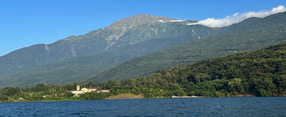
Monte Legnone – The Giant of the Orobie Alps
Monte Legnone, at 2,609 meters, is the highest peak in the province of Lecco and the western part of the Orobie Alps in Lombardy. Located between Valsassina and Valtellina, near Lake Como and Colico,
it is easily recognizable by its iconic pyramid shape overlooking the inverted “Y”-shaped Lario. The summit offers extraordinary views, including lakeside villages like Bellagio, historic villas, and spectacular Alpine panoramas.
🚗 How to reach Rifugio Roccoli Lorla
To reach Rifugio Roccoli Lorla (1,460 m), start from the village of Tremenico in Valvarrone, following a winding and scenic road that climbs through forests and pastures. The narrow road with numerous hairpin turns offers incredible views of Lake Como. The hut, with its small lake and parking area, is the perfect starting point for the hike.
🥾 Start and initial ascent
iBehnd the hut, we take the trail toward Monte Legnone, following the signs to Alpe Argogno. The beginning is gentle and gradual: the first sections, flat and shaded among larches and firs, allow us to get into the rhythm of the hike. My brother Claudio and I recall previous hikes here, noticing how the colors and details of the landscape always change, making each ascent unique.
🌲 Trail through woods and high pastures
After a short descent and some flat stretches near a small alpine hut, the trail starts climbing more decisively, zigzagging through clearings and woods. Alpe Argogno (1,644 m) offers a panoramic pause before the more challenging sections. The ascent here is steady but never excessively steep, allowing us to appreciate the alpine meadows and forest scents.
🪢 The ridge and equipped sections
Beyond the plateau, the trail becomes steeper and more technical, heading toward the exposed ridge. Here, fixed ropes, chains, and rocky footholds help us progress safely through the more difficult sections. The summit cross comes into view in the distance, motivating the final effort. Excitement grows with every step as we approach the peak.
🐄 Encounters along the way
During the ascent, we meet a shepherd with his dog and livestock, adding a touch of traditional mountain life that makes the hike even more authentic.
🏔 Summit of Monte Legnone (2,609 m)
The final stretch along the ridge leads to the large summit cross. The peak is not crowded, allowing us to fully enjoy the moment. Near the summit and on the surrounding slopes, we see ibex grazing, bringing life and movement to the panorama. We pause to admire the view, from Monviso to Ortles, including the Disgrazia, the peaks of Val Masino, Valle del Mera, and Lake Como. Claudio and I enjoy a sandwich kindly prepared by Elena, sitting among the rocks and meadows, watching the ibex and savoring the mountain’s peace. Every moment is a perfect balance of effort, emotion, and beauty.
🌤 Atmosphere and emotions
Eachh step along the trail allows us to relive memories of previous hikes, while discovering new colors and details of the mountain every time. My brother’s company makes the experience special, intertwining nature, history, and family bonds.
🔄 Return
The descent follows the same route through woods, plateaus, and ridges, leaving us with the satisfaction of having conquered the giant of the Orobie Alps.
✨ Why choose this hike
A challenging but rewarding experience, ideal for experienced or well-trained hikers seeking spectacular Alpine views, encounters with wildlife, and moments of genuine mountain contemplation.
Description – Monte Legnone
• Start & Finish 📍: Rifugio Roccoli Lorla (1,460 m) – return to the same point
• Trail type: Out-and-back on mule tracks, alpine trails, and equipped ridge
• Total distance 🥾: approx. 12 km
• Elevation gain ⛰️: 1,150 m
• Maximum altitude: 2,609 m (Monte Legnone summit)
• Average time ⏱️: 6–7 hours (round trip, including breaks)
• Difficulty: EE (expert hikers) – long steep ascent, exposed sections, rocky areas equipped with fixed ropes and steps
• Terrain: Dirt mule track, trails through woods and pastures, equipped ridge sections with ropes and chains
• Signage: Clear, white-red trail markers and local signs
• Exposure: South and west for most of the trail, exposed sections on the final ridge
Points of Interest
• Small lake and parking at Rifugio Roccoli Lorla
• Alpe Argogno and larch forests
• Flat sections through clearings and alpine huts
• Equipped ridges with ropes, chains, and rocky footholds
• Porta del Merli (2,129 m) and Bivacco Silvestri (Cà de Legn, 2,146 m)
• Summit of Monte Legnone (2,609 m) with cross and breathtaking panorama
• Observation of ibex grazing near the summit
• Views of Monviso, Ortles, Disgrazia, peaks of Val Masino, Valle del Mera, and Lake Como
• Map 📍: View Map
Trail Video 🎥 – GoPro Action Camera
• Video 1: Full hike from Rifugio Roccoli Lorla to the summit of Monte Legnone and back: ascent through forests with early panoramic views, equipped ridge, arrival at the summit, breathtaking panorama, grazing ibex, and return.
Trail Video & Photos 🎥 📸
• Video 2: Ascent from Rifugio Roccoli Lorla through forested sections and early panoramic views, equipped ridge, arrival at the summit, breathtaking panorama, observation of grazing ibex, and return.