

Murrin Loop & Jurassic Ridge Trail: Panoramic Hike near Squamish, British Columbia, Canada
The Murrin Loop Trail and Jurassic Ridge Trail are two beautiful hikes located north of Vancouver, between Britannia Beach and just south of Squamish, along the famous Sea-to-Sky Highway, within the stunning Murrin Provincial Park.
This natural park is a popular destination for hikers and climbers. At its heart lies Browning Lake, which offers swimming, picnicking, fishing, and a pleasant walking trail, perfect for a relaxing stroll before or after your hike. The park also features numerous rock walls and climbing opportunities, making it ideal for those seeking a vertical adventure.
A Short but Stunning Hike
The route follows a loop trail known as the Jurassic Ridge & Murrin Park Loop, often considered one of the most accessible hikes near Squamish. Despite its short length, the trail is classified as moderately challenging, mainly due to the technical section of the Jurassic Ridge Trail.
With a total length of about 3.2 km and an average gradient of 11.25%, the hike can be more strenuous than expected. The terrain is irregular and technical, with numerous roots, rocks, smooth slabs, and some rope-assisted sections, requiring attention and careful footing.
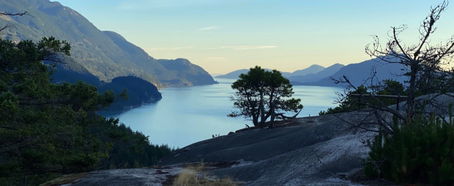
One of the most exciting parts of the hike is the climb up the smooth rock slab leading to the famous Quercus Viewpoint—a short but spectacular section that offers a thrilling sense of exposure and truly memorable panoramic views.
Access and Trailhead
The Jurassic Ridge Trail starts at the Murrin Provincial Park parking lot, near Squamish. During summer, it can be very busy, as families gather for picnics around Browning Lake and others come to fish. It’s recommended to arrive early to secure parking. Even off-season, sunny days can bring a fair number of visitors.
From the parking lot, the trail follows the north side of Browning Lake, passing the picnic area. During my hike, I noticed people fishing and others enjoying the lake, creating a pleasant and relaxed atmosphere.
Reaching the northwest side of the lake, the trail splits to the right into the forest: this is the Murrin Loop Trail, which forms the main part of the hike. Shortly after entering the loop, you come to a junction, where you can complete the circuit clockwise or counterclockwise.
During my experience, I chose the direction that climbs first to the initial viewpoint, allowing me to gradually enjoy the views and tackle the more technical Jurassic Ridge section at the highlight of the hike.
Trail Description
From the start of the Murrin Loop, the trail climbs through a dense forest, on terrain filled with roots, stones, and scattered rocks, typical of British Columbia trails.
After the first climb, you reach an intermediate viewpoint, where a wooden bench invites you to stop and enjoy the wide, relaxing view. The trail continues along steeper sections, passing by imposing vertical rock walls used for climbing, until reaching the rocky balcony of the Quercus Viewpoint.
From here, there’s a spectacular view of Howe Sound and the surrounding mountains—a true postcard landscape, impressive given the relatively low elevation and short length of the hike.
Descent and Loop Completion
After admiring the Quercus Viewpoint, the trail follows the “Descend” signs, descending steeply at times through the forest. After about 500 meters of forest trail, you reach the starting point at Browning Lake parking, completing the Murrin Loop & Jurassic Ridge Trail loop.
This makes the trail fully circular, without retracing any sections, offering a varied hiking experience with scenic views, forest, and technical sections throughout.
📌 Trail Information
• Start Point 📍: Murrin Provincial Park parking lot, near Squamish, BC, Canada
• Trail Type: Loop
• Distance 🥾: 3.2 km
• Time ⏱️: 1–2 hours
• Difficulty 💪 : Moderate (with short technical sections)
• Elevation Gain: Moderate, average gradient 11.25%
• Highest Point ⛰: Quercus Viewpoint
• Dog-Friendly 🐾: Yes, on leash
• Activities: Hiking, walking, swimming, picnicking, fishing, rock climbing
• Trail Map 📍: View the Map – Coming Soon