

Hike to Grignetta – from Piani dei Resinelli to the Summit (Grigna Meridionale, Lecco, Lombardy, Italy)
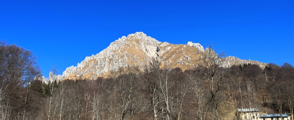
The Grignetta (Grigna Meridionale, 2,410 m / 7,907 ft) is one of the most iconic peaks of the Lombard Prealps. Its jagged shape, with ridges, pinnacles, and rocky walls, makes it spectacular both from a distance and for those hiking its trails to the summit.
The hike from the Piani dei Resinelli to Rifugio Carlo Porta and up to the summit is a complete alpine adventure, combining alpine nature, breathtaking panoramas, and technical sections. Along the way, hikers pass through shaded forests, grassy slopes, rocky sections, and mountain bivouacs, experiencing the true alpine atmosphere, with the perfect mix of effort and the satisfaction of reaching the top.
Start: Piani dei Resinelli
The hike begins at Piani dei Resinelli, a plateau in the Lombard Prealps located at around 1,200–1,300 m / 3,940–4,265 ft in the province of Lecco. At the foot of the Grignetta, the Piani dei Resinelli are a popular starting point for hikers and climbers. The area features open meadows, forests, alpine huts, and views over Lake Como. Historically used as pastures and mining zones, today they welcome tourists and mountaineers seeking adventure.
Ascent – from Rifugio Carlo Porta to the Summit
From the Piani dei Resinelli parking lot, follow the trail indicated towards Rifugio Carlo Porta. The first section winds through a shaded forest, providing relief and comfort, then opens onto a sunny grassy area. Here, the trail becomes steeper as you approach the Grignetta wall. The mist that accompanied us along the route created a mysterious and enchanting atmosphere, adding a unique charm to the climb.
After the refuge, there are sections equipped with chains, useful for safely navigating slippery rocks and exposed areas. Continuing up the grassy slopes, the gradient increases significantly. After the first steep section, the Grignetta wall comes into view. The path then continues over grassy and rocky sections toward the summit.
Along the way, hikers encounter the octagonal aluminum bivouac, nicknamed the “spaceship,” always open and usable as an emergency shelter. It’s a perfect spot for a short break before tackling the final rocky stretch to the summit.
Summit and Views
The Grignetta summit cross, at approximately 2,184 m / 7,162 ft, marks the end of the ascent. Nearby is the Bivacco Ferrario, available in case of emergency or for brief stops.
Due to fog, views of Lake Como, Lecco, and the surrounding mountains were limited, but on clear days, the vistas are spectacular. Reaching the summit provides a sense of achievement and satisfaction: every step, every slope, and every chain section is worth the effort.
Descent
The descent retraces the ascent route, passing again through grassy slopes, chain-assisted sections, and forested areas back to the Piani dei Resinelli. Along the way, hikers can observe pastures with cows, goats, and sheep, alpine huts, and refuges, making the return journey pleasant and scenic.
Conclusion
The Grignetta hike is a complete alpine adventure: effort, excitement, and breathtaking scenery combine throughout the route. Even in foggy conditions, the ascent offers unique sensations and a memorable alpine experience, from forests and grassy slopes to rocky sections, bivouacs, and the rewarding summit.
📌 Trail Details
• Start / Finish 📍: Piani dei Resinelli, main parking lot (Lecco, Lombardy, Italy)
• Distance 🥾: approximately 10–12 km round trip (~6–7.5 mi)
• Elevation gain ⛰: about 1,000 m (~3,280 ft)
• Estimated duration ⏱: 5–7 hours (including breaks and panoramic stops)
• Summit altitude ⛰️: 2,184 m / 7,162 ft (summit cross)
• Difficulty 💪: EE / F (Experienced Hikers, with chain-equipped sections, steep gradients, and rocky passages)
• Terrain / route 🛤️: mountain trails, forests, steep grassy slopes, rocky sections, chain-assisted passages
• Landmarks: Rifugio Carlo Porta, octagonal “spaceship” bivouac, Bivacco Ferrario, summit cross
• Panorama & environment: Lake Como, Lombard Prealps, valleys and forests, alpine pastures and huts
• Map 📍: Coming Soon