

Cycle Tour | Circumnavigation of the Iberian Peninsula: from the Mediterranean to the Atlantic and Back – Stage #4
🇫🇷 ➡️ 🇪🇸 Stage 4 | From France to the Portuguese border along the northern coast of Spain – from Hendaye (French Basque Country) to Belinho (Portugal)
Northern Spain, having never cycled it before, revealed itself as a wild and authentic land, perfect to explore slowly between the ocean and mountains, along one of Europe’s most spectacular coasts. Jagged cliffs, untouched beaches, green meadows, and forests accompany a journey far from mass tourism.
The route starts in Hendaye, on the French Basque coast, and continues to Irun, the gateway to the Camino del Norte, crossing four regions: Basque Country, Cantabria, Asturias, and Galicia. A continuous up-and-down between ocean and hills, sometimes sharing the road with pilgrims. Along the coast, iconic cities such as San Sebastián, Bilbao, and Gijón appear, while wind and climbs make the ride challenging yet incredibly rewarding.
Entering Galicia at Ribadeo, I leave the coast to follow the inland route to Santiago de Compostela, where the Cathedral marks the end of the Camino del Norte. For many pilgrims, this is the end of the journey. For me, however, it’s the start of continuing along the Portuguese Coast of the Camino Portugués: I follow the route in reverse, passing through Padrón, Pontevedra, Vigo, and Baiona, until reaching A Guarda, the last Spanish seaside town.
From the port, I take a short ferry across the Miño River to enter Portugal, beginning the ride along the northern Portuguese coast, with picturesque villages such as Vila Praia de Âncora, Viana do Castelo, and Castelo do Neiva, until reaching Parque de Campismo de Belinho, immersed in the calm of the Atlantic.
Cliffs, beaches, historic towns, and breathtaking scenery alternate with encounters with pilgrims and kind people, making this stretch of the Iberian Peninsula a unique adventure across France, Spain, and Portugal.
🇫🇷 ➡️ 🇪🇸 Stage 4.1 | Day 16: Camping Alturaran, Hendaye (French Basque Country) → Hostel Txalupa, Getaria (Spanish Basque Country)
I fell asleep to the sound of rain and woke up to the same gentle rhythm on the tent fabric. Moving quickly, I packed down the tent and carried it to the outdoor washing area, where a shelter kept everything dry. I spread out my gear and started packing the backpack.
While folding the still-damp rain layer of the tent, another cyclist appeared, doing the same tasks. His name was Erty, a Spaniard nearing the end of his cycling trip. In two days he would be back home in the Basque Country, where he had started his adventure. Since we were heading in the same direction, we decided to ride together.
As we rode, he told me he had completed several Caminos de Santiago, always on foot. One of his pilgrimages had started in Hendaye, in the picturesque Txingudi Bay, part of the natural border between France and Spain.
There is a ferry service between Hendaye and Hondarribia, used daily by locals and tourists, with bicycles allowed up to five per trip. We skipped the ferry and rode along the French Basque coast, then crossed the Puente de Santiago over the Bidasoa River, the natural border between the two countries.
On the Spanish side, we arrived at Azken Portu, a neighborhood of Irun full of wine, liquor, tobacco, perfume, souvenir, and clothing shops—a warm mix of Basque culture and landscapes. From here, my route officially joined the Camino del Norte, starting in historic Irún. Leaving the city, the road followed the coast near Errenteria, along parts of the EuroVelo 1 – Atlantic Coast Route.
Amid spectacular scenery, we reached Zurriola Beach, also known as Gros Beach, the main sandy stretch of the Gros district of San Sebastián (Donostia). The beach was long, almost deserted, with waves crashing as surfers danced in the water.
The cycle path continued along the Bay of Biscay, bringing us to the heart of San Sebastián, a city where elegant architecture, vibrant culture, and natural beauty coexist harmoniously. Near the estuary where rivers meet the sea (Itsasadarra in Basque), we crossed the La Zurriola Bridge over the Urumea River. Shortly after, we arrived at another beach, a golden crescent of calm waters with splendid views of Santa Clara Island and Mount Urgull.
Leaving Donostia, I stopped for a photo and realized I had taken a different route from Erty. Guided by Google Maps, I climbed the wooded hills just outside the city, surrounded by green and peaceful landscapes. From Talai Mendi hill in Zarautz, I paused again to admire the view of Zarautz Bay. Shortly after, by coincidence, Erty and I met again. Together, we descended to Playa de Zarautz, the “Queen of Beaches,” the longest sand stretch in the Basque Country and a true surfers’ paradise.
After more photos, we continued to Getaria, a charming medieval fishing village on the Urola coast. We stayed at Hostel Txalupa Getaria, booked that morning by Erty. When I handed over my Canadian passport at check-in, the owner noticed and showed me his maple leaf bracelet, a gift from a traveler he had met in the past.
The hostel, designed for Camino de Santiago pilgrims, was spotless, well-organized, and run by a welcoming owner. We slept in separate dormitories, but later met to dry our tents in a grassy area near the Elcano Monument, a stone tribute at the entrance to Getaria’s historic center with stunning coastal views.
That evening, we wandered the streets, stopping for an aperitif (Coca-Cola for me, beer for him) and tapas for both, before grocery shopping. Back at the hostel, we cooked dinner in the communal kitchen and reviewed the next day’s route.
Hostels have never really been my style; my small tent always feels more like home, but I fell asleep quickly, knowing that the next day would bring more ocean views, hills, and breezy Basque rides.
📌 Route information and footage with GoPro
• Region / Area 🌍 : 🇫🇷 French Basque Country / 🇪🇸 Spanish Basque Country
• Main Locations 🏘 :Camping Alturaran, Hendaye → Irun → San Sebastián (Donostia) → Zarautz → Getaria
• Distance 🚴 : ~65 km
• Total Time ⏱️ : [.....], including scenic and photo stops
• Terrain 🛣️ : Secondary roads, coastal cycle paths, mixed urban and hilly routes
• Direction 🧭 : West → East along the Basque coast
• Route Map 📍: View the map
🇪🇸 Stage 4.2 | Day 17: Hostel Txalupa, Getaria → Camping Saturraran, Mutriku (Gipuzkoa, Basque Country, Spain)
We woke up early at Hostel Txalupa in Getaria and, right after breakfast, set off. We cycled along the stunning Basque coast under a cloudy sky, passing through Zumaia, famous for its two geologically unique beaches and the spectacular layered Flysch cliffs.
Continuing on, we crossed the Urola Ibaia area and the town of Deba. My friend decided to follow the pilgrim route on the Camino del Norte, a path he already knew. The beginning was paved, but soon it turned into gravel and dirt, transforming into a true “bike-hike”, more like carrying the bike on foot.
The climb led to a viewpoint, Behatokia Mirador, just a few minutes on foot, offering breathtaking coastal views and a small food truck where we met other pilgrims. We then continued on paved roads to Deba-Itziar at 225 meters, before descending toward the coast and the town of Deba. Here I bought the Camino de Santiago booklet (credencial) to stamp at each stage.
After a short lunch break, we pedaled to Mutriku. Here we said our goodbyes: my friend continued his journey, while I stayed for the night and set up my tent at Camping Saturraran, a well-kept campsite just 200 meters from the beach and near the Flysch rock formations.
The evening ended with dinner at the campsite restaurant, and as the temperature dropped, I crawled into my sleeping bag, ready for the next day.
📌 Route information and footage with GoPro
• Region / Area 🌍 : Basque Country, Spain
• Main Locations 🏘 :Hostel Txalupa, Getaria → Zumaia → Deba → Camping Saturraran, Mutriku
• Distance 🚴 : ~~55 km
• Total Time ⏱️ : [.....], including scenic and photo stops
• Terrain 🛣️ : Coastal roads, gravel and dirt paths, hilly climbs
• Direction 🧭 : East along the Basque coast
• Route Map 📍: View the map
🇪🇸 Stage 4.3 | Day 18: Camping Saturraran, Mutriku → Pension Martinez, Bilbao (Basque Country, Spain)
Basque Country: Spain – Coast, hills, and Basque cities
This morning, before leaving the campsite, I met Yohanda at the restaurant, a friend of the owner, who had already paid for everything on my behalf. Shortly after, Maurizio, an Italian chef from the area, arrived. I took a photo with him and exchanged a few words before saying goodbye to both of them.
After leaving the campsite, the route initially followed the Basque coast, then veered inland, passing through green countryside and rolling hills, including Mentreda and Markina-Xemein.
In Mallabia, I faced a challenging climb of 3.2 km up to 440 meters, with an average gradient of 4.6% and sections reaching 8.9%. After the effort, a long descent brought me to Bilbao, the capital of Bizkaia. Following the bike path along the Nervión River, I reached Pension Martinez, where I spent the night.
In the afternoon, I explored the city on foot, walking along the river with its elegant bridges, well-kept gardens, and urban architecture. I also visited the Guggenheim Museum, famous for contemporary art and futuristic architecture. Before returning, I did some grocery shopping for dinner, and back in my room, I checked the route for the next day before going to sleep.
📌 Route information and footage with GoPro
• Region / Area 🌍 : Basque Country, Spain
• Main Locations 🏘 :Camping Saturraran (Mutriku) → Mentreda → Markina-Xemein → Mallabia → Bilbao
• Distance 🚴 : ~69.4 km
• Total Time ⏱️ : [.....], including scenic and photo stops
• Terrain 🛣️ : ~69.4 km
• Direction 🧭 : E/SE → S/W toward Bilbao
• Route Map 📍: View the map
🇪🇸 Stage 4.4 | Day 19: Pension Martinez, Bilbao → Camping Laredo, Laredo (Cantabria, Spain)
The day started with sunshine and a clear blue sky, perfect for cycling. After breakfast in my room, I loaded my bike and bags and set off along the bike path toward El Carmen, Barakaldo, admiring the large green globe sculpture.
The route meandered through green valleys and open fields, dotted with horses grazing, until I reached Zierbena on the Biscay coast. From Playa de la Arena, I continued toward Castro Urdiales, following cliffside stretches with spectacular views of the Atlantic.
After a brief merge with the main road and a steady climb, I tackled a steep 10% descent toward Mioño, then continued toward Islares, popular with surfers. Inland, I passed through Liendo and Tarrueza, finally reaching Laredo, a charming town in Cantabria.
At Camping Laredo, I pitched my tent, explored a nearby stable, and had dinner at the campsite restaurant, taking the chance to recharge my devices. The evening ended with a light rain on the tent, while I checked the route for the next day.
📌 Route information and footage with GoPro
• Region / Area 🌍 : Basque Country → Cantabria
• Main Locations 🏘 : Bilbao → Barakaldo → Ortuella → Zierbena → Playa de la Arena → Castro Urdiales → Ontón → Mioño → Islares → Liendo → Laredo
• Distance 🚴 : ~75.7 km
• Total Time ⏱️ : [.....], including scenic and photo stops
• Terrain 🛣️ : Paved roads, coastal paths, minor climbs and descents, scenic coastal stretches
• Direction 🧭 : East → West, along the Cantabrian coast
• Route Map 📍: View the map
🇪🇸 Stage 4.4 | Day 20: Camping Laredo, Laredo → Camping de Comillas, Comillas (Cantabria), Spain
Cantabria: Coast, greenways, and historic villages
I woke up early at Camping Laredo, I packed everything calmly, organized the bags, and loaded the racks. Leaving the campsite, I passed through the stables and the small fishing village of Laredo, still wrapped in a peaceful atmosphere, with glimpses of the sea on the horizon.
For pilgrims walking the Camino del Norte, crossing the bay that separates Laredo from Santoña is done by small boats; for me on a bike it was impossible, so I chose the most practical route, crossing the Ría de Treto via the bridge. Google Maps guided me along Calle La Tejera, a winding dirt road running parallel to the highway. The climb was steep and long: for much of it, I had to push the bike on the toughest slopes.
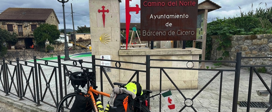
At the top, in the rural area of Bárcena de Cicero, I found green fields and cows grazing, with a small Camino del Norte sign indicating the pilgrims’ route. The dirt road then gave way to the N-634, a rolling road immersed in the open and bright landscapes of the countryside. I passed Beranga, Praves de Medio Cudeyo, and reached Solares, avoiding Santander and following the inland route through hills, cultivated fields, and grazing animals.
Before La Encina, a beautiful bike path led me to the Vía Verde del Pas, a quiet stretch along the Suscuja River, through fields of golden wheat and silent landscapes perfect for cycling without hurry. Along gentle ups and downs and local roads, I passed Varga, Sierrapando, Torrelavega, Puente San Miguel, Vispieres, Santillana del Mar, Oreña, Cóbreces, and Ruiloba, a succession of villages and ever-changing panoramas, breathing in the true essence of Cantabria.
The road finally opened up to views of the sea, bringing me to Comillas, famous for its modernist architecture and Gaudí’s El Capricho. Crossing the bridge, I arrived at Camping de Comillas, quiet despite the low season. I did some shopping at the small onsite market, and thanks to Amalia, the kind and caring shopkeeper, I was able to heat up my food and bring it comfortably to the tent.
The evening ended with a walk on the beach, observing Comillas surprisingly lively and beautiful even at sunset. Back at the tent, I organized my usual evening things and fell asleep, satisfied after an intense day between coast, hills, and historic villages.
📌 Route information and footage with GoPro
• Region / Area 🌍 : Basque Country → Cantabria
• Main Locations 🏘 : Laredo → Bárcena de Cicero → Beranga → Solares → Castañeda → Torrelavega → Santillana del Mar → Comillas
• Distance 🚴 : ~78.6 km
• Total Time ⏱️ : [.....], including scenic and photo stops
• Terrain 🛣️ : River bike paths, secondary roads, coastal cliff stretches, short but intense climbs and descents, some main road sections
• Direction 🧭 : East → West, along the Cantabrian coast
• Route Map 📍: View the map
🇪🇸 Stage 4.5 | Day 21: Camping de Comillas, Comillas → Hotel Argüelles, Ribadesella (Asturias), Spain Cantabria → Asturias: Atlantic coast, Camino del Norte, and fishing villages
The sky was low and gray from the morning, almost pressing down on the horizon. After packing up the tent, I unlocked Girasole, reattached the bags, and got back on the bike along the quiet coast. The cliffs plunged into the restless ocean, while the air carried scents of salt and wet grass.
I soon reached the Puente de la Maza, an elegant 15th-century medieval bridge connecting San Vicente de la Barquera to its surroundings. Next to the bridge, an iron statue of a pilgrim and a bench engraved with “Caminos Lebanon” reminded me of the far-reaching influence of the Camino de Santiago. From there, the view embraced the Oyambre Natural Park, the town’s waterfront, and the Río Escudo estuary, whose still waters mirrored the gloomy sky.
Following the yellow arrows and shell symbols, I cycled through Pesués, El Peral, Colombres, Bustio, and La Franca. At Buelna, the Camino offered two options: a rugged coastal path or the main road; I chose the latter, gentle and lightly trafficked, with regular climbs and descents.
Beyond Pendueles, the route became a dirt track through grassy hills, pastures with cows, and moss-covered stone walls, opening up to the plain of Porrúa, with its country houses and the small church of San Julián and Santa Basilisa.
About fifteen kilometers from Llanes, Playa de San Antolín appeared, a wide and wild beach, where a few surfers moved among the waves. I stopped at a scenic viewpoint, letting the fresh Atlantic wind brush my face and taking some photos before continuing along a coastal bike path to Nueva, where a spectacular viewpoint revealed a natural arch emerging from the sea and completely deserted beaches beneath the clouds.
In the afternoon, I arrived in Ribadesella, a lively town on the northern coast of Asturias. The green hills gently sloped toward the sea, and the Sella River divided the historic center from the modern waterfront. A bridge connected the ancient heart, with its cobblestone streets, centuries-old houses, flowered balconies, and bustling port, to the long beach of Playa de Tito Bustillo.
My accommodation, the Hotel Argüelles, was simple but cozy, located in the historic district near the port. The manager secured Girasole in a safe spot before showing me to a room with terracotta roof views. I wandered a bit more through the town center, where colorful fishing boats swayed slowly on the calm water. When a light rain started, I returned to the hotel, stopping at some shop windows and a small supermarket to buy something for dinner.
In my room, I ate in silence, listening to the steady patter of rain on the windows. Before falling asleep, I checked Google Maps and Komoot for the next day’s stage, satisfied after an intense day along the wild coast, historic villages, and spectacular landscapes.
📌 Route information and footage with GoPro
• Region / Area 🌍 : Cantabria → Asturias
• Main Locations 🏘 : Camping de Comillas → Laredo → Bárcena de Cicero → Porrúa → Playa de San Antolín → Nueva → Ribadesella (Hotel Argüelles)
• Distance 🚴 : ~80.3 km
• Total Time ⏱️ : [.....], including scenic and photo stops
• Terrain 🛣️ : Paved roads, coastal bike paths, short dirt sections
• Direction 🧭 : West → East along the northern coast of Spain
• Route Map 📍: View the map
🇪🇸 Stage 4.6 | Day 22: Hotel Argüelles, Ribadesella → Hotel Avenida, Gijón (Asturias), Spain
Asturias – Atlantic coast, Camino del Norte, and rural landscapes
Upon waking, the forecast was confirmed: it was raining. Breakfast was simple, with a bottled cappuccino, two croissants, and a banana I had bought the night before at the supermarket.
I set off in light rain, crossing the east side of Ribadesella’s historic center, passing over the Sella River bridge, and continuing west past San Esteban, Caravia Alta, and Prado. Pilgrims in rain ponchos moved slowly, greeting me with a cheerful “¡Buen Camino!”
At times, the road opened up to the ocean, where the gray sky hung low over the horizon. Fine rain created ripples on the water surface, while the waves churned, streaked with white foam. The air smelled of salt and wet stone, and the wind carried the sound of the waves, sometimes muffled, sometimes loud.
At Playa de la Espasa, I stopped for a few photos: the deserted, wind-swept beach felt alive and untamed, yet peaceful in its solitude. The path was crowded with pilgrims on foot, while other cyclists were few.
Near Colunga, famous for dinosaur footprints, I passed the turnoff to the Jurassic Museum of Asturias, not stopping due to the humid air. I found shelter under a porch and sat on a stone bench until the heavier rain passed.
The road then climbed through green, rural landscapes: scattered houses on hillsides, fields bordered by dry-stone walls, and cows grazing. Passing Villaviciosa, the “Apple Capital” of Asturias, I crossed the Partial Natural Reserve of the Ría de Villaviciosa, a quiet estuary where river and sea meet under light rain. Eucalyptus trees lined the road, cut logs were neatly stacked outside a small carpentry shop, and the air smelled of rain and fresh grass.
Crossing El Pedrosu and La Esperanza, I tackled hill climbs and descents before finally reaching Gijón, the largest city in Asturias, still shrouded in steady rain.
At Hotel Avenida, just 550 meters from Playa de Poniente, I stored the bike, hung wet clothes to dry, and treated myself to a long, hot shower. I went out only for dinner at the supermarket, eating in the warmth of the hotel. No sightseeing that evening: after so many hours cycling in the rain, relaxation took priority. Checking the next day’s stage on Google Maps and Komoot, I fell asleep to the steady rhythm of rain on the windows, satisfied with the day.
📌 Route information and footage with GoPro
• Region / Area 🌍 : Asturias, Spain
• Main Locations 🏘 :Ribadesella → San Esteban → Caravia Alta → Prado → Playa de la Espasa → Colunga → Villaviciosa → El Pedrosu → La Esperanza → Gijón (Hotel Avenida)
• Distance 🚴 : ~76.4 km
• Total Time ⏱️ : [.....], including scenic and photo stops
• Terrain 🛣️ : Coastal bike path, rural roads, hill climbs and descents
• Direction 🧭 : East → West
• Route Map 📍: View the map
🇪🇸 Stage 4.7 | Day 23: Hotel Avenida, Gijón → Camping Yolimar, Cudillero (Asturias), Spain
Asturias – Atlantic coast, Camino del Norte, and fishing villages
The morning woke up clear and fresh, with a blue sky urging me to start immediately. Breakfast was simple: bread, fruit, and yogurt bought the night before at the supermarket, enjoyed by the open window, with the crisp air flowing in gently.
Heading down, I took the bike from the storage, greeted the receptionist with a cheerful “good morning,” and went out onto the bike path in front of the hotel. Gijón was quiet under the morning light. I got lost in the historic center, following narrow streets and letting the scent of the sea guide me.
Soon, the seafront opened before me, leading to Playa de Poniente, with golden sand and calm waters. Leaving Gijón, the road alternated between wide bike avenues and narrow streets, almost like secret paths. The yellow arrows of the Camino del Norte appeared everywhere: on poles, walls, and small painted signs. I cycled through cultivated fields, grazing horses, lazy cows, and tall cornfields swaying in the wind.
The towns along the route were small and peaceful, each with its quiet charm. A low underpass led me to Corvera, from where a rural bike path took me to Avilés, along the estuary. The air smelled of river and sea, with wide, open views. Across the water, the Oscar Niemeyer International Cultural Center rose monumental, with white curves and red and yellow details, perfect for photographing.
Further along, the port of Avilés showed swaying boats and the 30-meter sculpture by Benjamin Menéndez, like silent lighthouses in the sky. The road climbed to Piedrasblancas, descended to Soto del Barco, crossed the wide Río Nalón, and continued toward Muros de Nalón, until reaching Cudillero, a picturesque fishing village nestled between mountains and sea.
At Camping Yolimar, almost deserted in low season, I pitched the tent in a perfect spot. Dinner was at the neighboring restaurant: simple, plentiful, and fish-based, ideal after a long day on the bike.
Back at the campsite, I followed my evening routine: checking the next day’s stage, organizing equipment, and finally slipping into the sleeping bag, lulled by the distant, quiet sound of the sea.
📌 Route information and footage with GoPro
• Region / Area 🌍 : Asturias, Spain
• Main Locations 🏘 : Gijón → Corvera → Avilés → Piedrasblancas → Soto del Barco → Muros de Nalón → Cudillero (Camping Yolimar)
• Distance 🚴 : ~66.0 km
• Total Time ⏱️ : [.....], including scenic and photo stops
• Terrain 🛣️ : Castal bike path, rural roads, hilly sections
• Direction 🧭 : East → West
• Route Map 📍: View the map
🇪🇸 Stage 4.8 | Day 24: Camping Yolimar, Cudillero (Asturias) → Hostal El Pinar, Ribadeo (Galicia), Spain
Asturias → Galicia – Atlantic coast, Camino del Norte, and fishing villages
I woke up at Camping Yolimar under a clear blue sky. I packed up the tent, loaded the bags on the bike, and set off along a route of continuous climbs and descents, through gentle green hills and peaceful countryside.
After leaving the campsite, I passed through Martín de Luina and soon reached Soto de Luiña, a small village along the Camino del Norte. Here, I had breakfast at a café with outdoor tables, sharing the pause with other pilgrims who, like me, were on their journey.
Continuing, the road followed the coast through Valdredo, Novellana, Valdés Tablizo, Ribón, and Camero, until reaching Luarca, a charming fishing port. Later, I arrived at Navia, on the Ría de Navia, and stopped for a photo on the bridge, exchanging a few words with a fellow pilgrim along the way.
From Castropol, I followed a rural bike path to the Puente de los Santos, crossing the Río Eo and entering Galicia. The wind whipped across the bridge, the ocean opened wide beneath me, and the distant coastline seemed endless.
Beyond the river, quiet agricultural trails led me to Ribadeo in northern Galicia. My stop for the night was at Hostal El Pinar, convenient for both the beach and the town center. After check-in, I organized the bags in a spotless roomand explored the hostel gardens, with barbecue areas and a small playground.
Dinner was simple, at a restaurant just across from the hostel. In the room, I followed my evening routine: checking the next day’s route and preparing for rest, lulled by the silent sound of the distant sea.
📌 Route information and footage with GoPro
• Region / Area 🌍 : Asturias → Galicia
• Main Locations 🏘 : Cudillero → Martín de Luina → Soto de Luiña → Valdredo → Novellana → Valdés Tablizo → Ribón → Camero → Luarca → Navia → Castropol → Puente de los Santos → Ribadeo
• Distance 🚴 : ~102 km
• Total Time ⏱️ : [.....], including scenic and photo stops
• Terrain 🛣️ :Rural roads, green hills, coastal trails
• Direction 🧭 : East → West
• Route Map 📍: View the map
🇪🇸 Stage 4 | Day 25: Hostal El Pinar (Northern Galicia), Ribadeo → Albergue de Peregrinos de Baamonde, Begonte, Spain
Galicia – Inland routes, rolling hills, and historic villages
I woke up at 7:00 AM at Hostal El Pinar, under a clear, sunny sky. After getting ready, I crossed the street for a quick breakfast at a café-restaurant, before leaving Ribadeo for good.
Less than 25 km later, I passed through Miguel de Reinante and Barreiros, between the Masma River estuary and the Ribadeo area. The Atlantic Ocean slowly receded from view, while the route ventured into the inland of Galicia.
The landscape changed to rolling hills and small mountainous elevations, green and peaceful, full of climbs and descents. Along the way, I passed Lourenzá, Mondoñedo, Abadín, and the historic Vilalba, where I stopped briefly in front of the picturesque neo-Gothic cemetery of Goiriz.
Towards evening, I reached my destination: Baamonde, a small village in the municipality of Begonte, Lugo province. A traditional Camino del Norte stop, Baamonde sits at a crossroads frequented by pilgrims in transit.
I stayed at the Baamonde Pilgrims’ Hostel, a simple public albergue converted from an old stagecoach depot, reserved exclusively for pilgrims. At check-in, the receptionist asked to see my pilgrim passport.
When I handed it over, she was surprised: there was only one stamp, unusual for someone so close to the end of the Camino del Norte. I explained that I don’t collect stamps for recognition; the true satisfaction is completing the route, as I do with all my bike journeys.
After settling in, I wandered through the village until a small supermarket opened, frequented by other travelers and pilgrims, many of whom spoke Italian. I bought dinner, heated it in the hostel microwave, and spent some time in the common room recharging equipment and checking the map for the next day.
As evening fell, I climbed into my bunk bed (the lower spots were all taken) and fell quickly into a deep sleep, with another day of cycling behind me.
📌 Route information and footage with GoPro
• Region / Area 🌍 : Northern Galicia
• Main Locations 🏘 : Ribadeo → Miguel de Reinante → Barreiros → Lourenzá → Mondoñedo → Abadín → Vilalba → Baamonde (Albergue de Peregrinos)
• Distance 🚴 : ~85.2 km
• Total Time ⏱️ : [.....], including scenic and photo stops
• Terrain 🛣️ : Rolling hills, rural roads, small mountainous elevations
• Direction 🧭 : East → West
• Route Map 📍: View the map
🇪🇸 Stage 4.10 | Day 26: Albergue de Peregrinos de Baamonde, Begonte → Camping As Cancelas, Santiago de Compostela, Spain
Galicia – Inland and arrival at Santiago de Compostela
I woke up earlier than usual at the Albergue de Peregrinos de Baamonde. The pilgrims in the room were already moving, while outside it was still dark. I got up calmly, not wanting to cycle in the dark. After a quick shower, I had breakfast quietly in the common room.
With the first light of day, I left Baamonde and joined the road shared with cars and pilgrims. Soon I reached Toar, a small village of Guitiriz, where a blue sign with the yellow Camino de Santiago shell pointed me to a short shaded trail. The path was silent, immersed in vegetation, and at times ran alongside the Río Parga.
The trail then opened onto a quiet rural road through Guitiriz, among rustic houses and marshy fields. I cycled for a long stretch without seeing a soul, accompanied only by the steady rhythm of the wheels.
The stage continued along a scenic provincial road through rolling hills, low mountains on the horizon, and mosaic fields. I passed the small villages of Mesía, Frades, and Marquino, immersed in an increasingly peaceful and rural landscape.
In the final section, a dirt trail led me to Camping As Cancelas, perched on a hill above Santiago de Compostela. After check-in, I pitched the tent in a quiet corner, surrounded by trees, with an open view of the valley. The campsite felt like a small paradise, with a pool, restaurant, bar, and even a shopping center a few minutes away, where I went to buy dinner.
The evening passed slowly, with a relaxing walk around the almost empty campsite. I could have taken the bus to visit Santiago de Compostela at night, but I decided to wait.
Tomorrow I would finally reach the Cathedral of Santiago, the goal of the Camino del Norte for most pilgrims. For me, however, it would not be an end, but the beginning of a new chapter of my circumnavigation of the Iberian Peninsula. I fell asleep with a feeling of anticipation, ready to experience one of the most significant moments of the journey.
📌 Route information and footage with GoPro
• Region / Area 🌍 : Northern Galicia
• Main Locations 🏘 : Baamonde → Toar → Guitiriz → Mesía → Frades → Marquino → Santiago de Compostela (Camping As Cancelas)
• Distance 🚴 : ~85.5 km
• Total Time ⏱️ : [.....], including scenic and photo stops
• Terrain 🛣️ : Rural roads, gravel trails, rolling hills
• Direction 🧭 : North → Southwest
• Route Map 📍: View the map
🇪🇸 Stage 4.11 | Day 27: Camping As Cancelas, Santiago de Compostela → Camping Playa Samil, Vigo, Spain
Galicia – Arrival in Vigo and start of the Portuguese Coastal Way
This morning I woke up very early, as often happens while traveling. The days were getting shorter, and with the early arrival of evening, the hours available for cycling were also fewer. After packing up the tent and taking a moment to admire the sunrise, I loaded the bags on the bike and stopped at the campsite café for a quick breakfast.
A short descent took me into the heart of Santiago de Compostela, where the Cathedral rose majestically before me. The square was alive, with pilgrims from all over the world celebrating the end of their journey. We exchanged smiles, congratulations, and photos, sharing a unique moment.
For me, this place marked the end of over 800 km along the Camino del Norte, through the Basque Country, Cantabria, Asturias, and Galicia. But it was not really an end: it was the start of a new adventure, the Portuguese Coastal Way towards Porto.
Leaving the historic center, I passed through Ames, cycling on roads frequented by pilgrims. The route, well marked with shells, guided me to Valga, in the province of Pontevedra.
Arriving at Pontevedra, I crossed the picturesque Ponte do Burgo over the Lérez River, then continued on the modern Ponte de los Correntes, reserved for pedestrians and cyclists. After a stretch, the bike path ended, and I had to rely on Google Maps to find the route along the river.
The route continued through natural scenery and small towns like Soutomaior, Cabanas, and Rande, where the coast began to reappear on the horizon.
In the afternoon, I reached Vigo, passing through the city center and the large fishing port, one of the most important in Europe. The city faces the Ría de Vigo, protected by the spectacular Cíes Islands.
Just a few more kilometers and I arrived at Camping Playa Samil, right in front of the beach. After check-in, I pitched the tent and went for a walk along the promenade.
At sunset, I returned to the Playa de Samil: a long stretch of light sand and open sea, with the islands visible in the distance under a clear sky.
The day ended as usual: a simple dinner, checking the next day’s route, and then into the sleeping bag, accompanied by the calm sound of the waves.
📌 Route information and footage with GoPro
• Region / Area 🌍 : Galicia, Spain
• Main Locations 🏘 : Santiago de Compostela → Ames → Valga → Pontevedra → Soutomaior → Cabanas → Rande → Vigo (Camping Playa Samil)
• Distance 🚴 : ~106 km
• Total Time ⏱️ : [.....], including scenic and photo stops
• Terrain 🛣️ : Urban roads, bike paths, provincial roads
• Direction 🧭 : Northeast → Southwest
• Route Map 📍: View the map
🇪🇸 🇵🇹 Stage 4.12 | Day 28: Camping Playa Samil, Vigo (Spain) → Parque de Campismo de Belinho, Belinho (Portugal)
Galicia → Portuguese Coast – Portuguese Coastal Way and seaside villages
This morning I expected to wake up under a clear sky, after the fiery sunset of the previous evening. Instead, the atmosphere was surreal: the sky a pale yellow, the sun a dull red disc, and the air thick with smoke, probably from fires in Portugal.
After the usual morning routine, I departed, cycling through Vigo shrouded in haze, heading northwest. Gradually, the city remained behind, and the landscape opened up between sea and mountains, passing through Nigrán, known for its beaches, including Playa América, wide and bright even under the unreal sky.
The flat coastline accompanied me to Baiona, a charming medieval village with a lively port, a long beach, and the promenade surrounding Monte Boi, dominated by Castillo Monterreal.
From here, the Portuguese Coastal Way follows the ocean faithfully: waves, cliffs, and endless beaches. At Oia, however, the smoke was so dense that I had to stop at a service station to look for a mask. It was not for sale, but the attendant kindly gave me his.
The road continued to offer spectacular views up to A Guarda, the last Spanish seaside village. From the port, I took a small ferry to cross the Minho River and enter Portugal. The crossing was short but atmospheric, shared with other pilgrims waiting.
On the other bank, I reached Vila Praia de Âncora, a picturesque fishing village on the Atlantic. I stopped for a few photos at the Forte da Lagarteira, among boats and beaches stretching to the horizon, though the colors remained muted by the haze.
Continuing along the coast, I reached Viana do Castelo, where the Lima River meets the sea. I crossed the historic center, among alleys and cafés, then went to the port to see the Gil Eannes, a former hospital ship now converted into a museum.
The final stretch took me along the promenade and then across the Eiffel Bridge over the Lima, continuing towards Castelo do Neiva, where I met a young pilgrim on his way to Santiago. After a brief chat, I resumed the road to the final destination.
I arrived at the Parque de Campismo de Belinho, in the municipality of Esposende, immersed in the peace of the Atlantic coast. The campsite was almost empty. I pitched the tent, accompanied only by a few discreet stray cats.
A few steps away, Praia do Belinho stretched wild between the mouth of the Cávado and Neiva rivers. It was the last image of the day: ocean, silence, and a sky still veiled with smoke.
📌 Route information and footage with GoPro
• Region / Area 🌍 : Galicia (Spain) → Northern Portugal (Minho Coast)
• Main Locations 🏘 :Vigo → Nigrán (Playa América) → Baiona → Oia → A Guarda → ferry across Minho River → Vila Praia de Âncora → Viana do Castelo → Castelo do Neiva → Belinho
• Distance 🚴 : ~92.4 km
• Total Time ⏱️ : [.....], including scenic and photo stops
• Terrain 🛣️ : Coastal roads, promenades, flat sections, gentle undulations, short ferry crossing
• Direction 🧭 : Northwest → South, along the Atlantic coast
• Route Map 📍: View the map