

Cycle Tour | Circumnavigation of the Iberian Peninsula: from the Mediterranean to the Atlantic and Back – Stage #2
🇮🇹 ➡️ 🇫🇷 Stage 2 – From Ventimiglia, Italian Riviera, to the French Mediterranean Coast: Ventimiglia → Le Barcarès, Pyrénées-Orientales (Occitanie, France)
→
Overview
Starting from Ventimiglia, I quickly crossed into France. Menton and Ventimiglia are two towns divided by the border between Italy and France. Ventimiglia, the last town on the western Ligurian coast, lies just before the frontier, at the foothills of the Alpes-Maritimes, where hills gently descend toward the Côte d’Azur.
I cycled through picturesque villages, vineyards, and valleys before following the southern French Mediterranean coast, where lagoons, salt flats, and natural reserves are home to pink flamingos. From the sea at Sète to Le Barcarès, every pedal stroke revealed breathtaking views, intense light, and vibrant colors.
🇮🇹 ➡️ 🇫🇷 Stage 2.1 | Day 2: Camping Roma, Ventimiglia, Italy → Camping Les Pruniers, Mandelieu-la-Napoule, France
The day began under a clear, already warm sky. After a quick breakfast at the campsite bar, I packed up the tent and headed west along the Via Aurelia. Crossing the Roya River, the road started to climb gently just enough to wake up my legs. Soon after, with the watercolor tones of the Balzi Rossi behind me, the Italian coast gave way to France.
Entering Menton, the first town of the French Riviera, felt natural: pastel façades, the scent of the sea, and a relaxed atmosphere. Between Menton and Nice, three scenic roads unfold Basse, Moyenne, and Grande Corniche each offering a different perspective of the coast. I chose the Basse Corniche, closest to the sea, smooth and bright, suspended between beaches and the deep blue Mediterranean, passing through Roquebrune-Cap-Martin and Monaco.
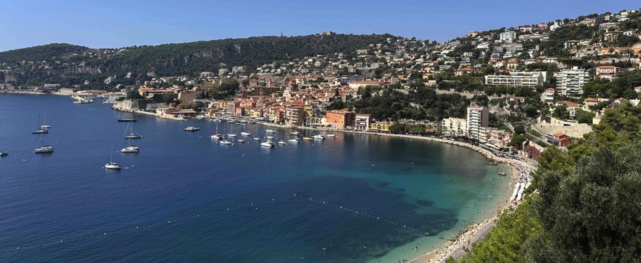
The road kept climbing without ever losing sight of the sea. At Èze-sur-Mer, a tunnel closure forced me onto a narrow side road regulated by traffic lights a surprise that turned into a gift, with spectacular views over Villefranche-sur-Mer, where the blue of the water meets the green of the hills.
Viewpoints followed one after another. I stopped several times, breathing in the salty air, before descending toward Nice. In the city, I followed the Promenade des Anglais, riding along the seafront bike path between palm trees, open sea, and the intense light of the Bay of Angels.
The route then continued through Villeneuve-Loubet, Saint-Laurent-du-Var, and Cagnes-sur-Mer, leading to Antibes, a town blending artistic charm with seaside villas and historic character.
Beyond Antibes, the road brought me to Cannes, where I cycled along the iconic Promenade de la Croisette, lined with palm trees, elegant hotels, and Riviera beaches.
By late afternoon, I reached Mandelieu-la-Napoule, known for its beaches, the Château de la Napoule, and the Mimosa Festival. Here I ended the day at Camping Les Pruniers: an intense and luminous stage, filled with sea views, scenic curves, and roads that already felt like the beginning of a great journey.
📌 Route information and footage with GoPro
• Region / Area 🌍: Ligurian Riviera → Côte d’Azur (French Riviera)
• Main Locations 🏘 : Ventimiglia 🇮🇹 → Menton 🇫🇷 Roquebrune-Cap-Martin → Monaco → Èze-sur-Mer → Villefranche-sur-Mer →Nice, Villeneuve-Loubet → Saint-Laurent-du-Var → Cagnes-sur-Mer → Antibes → Cannes → Mandelieu-la-Napoule
• Distance 🚴 :86.4 km
• Total Time ⏱️: 7:11 hours, including scenic and photo stops
• Terrain 🛣️ ️: Coastal paved roads, moderate climbs (Corniche roads), urban bike paths, and scenic descents
• Direction 🧭 ️: West → East along the Mediterranean coast
• Route Map📍: View the map
🇫🇷 Stage 2.2 - Day 3: Camping Les Pruniers, Mandelieu-la-Napoule, France → Camping La Condamine, Hyères-les-Palmiers I France
French Riviera – Coast and Massif de l’Esterel
After leaving the campsite on a warm, sunny morning, I began pedaling through Mandelieu-la-Napoule, following the navigable course of the Siagne River and passing by the magnificent Château de la Napoule, a restored medieval fortress elegantly overlooking the coast.
Shortly after, the road led me to Théoule-sur-Mer and along the famous Corniche de l’Esterel, or Corniche d’Or, a spectacular route skirting the red cliffs of the Massif de l’Esterel. Between turquoise coves and rocky headlands, the scenery reminded me of the wild beauty of Big Sur on California’s State Route 1 a memory of my cycling trips years ago.
Beyond Saint-Raphaël, I passed through Fréjus, calmer and more intimate compared to nearby Saint-Tropez, and then Port Grimaud, a postcard-perfect lagoon village with ferries to the famous glamorous destination.
I could have continued along the coast to Saint-Tropez, overlooking the Gulf and famous for its beaches, port, luxury shopping, and glamorous atmosphere attracting jet-setters and celebrities. However, being the peak of summer, the town and surroundings were crowded with yachts, boutiques, and busy venues. I preferred to leave this bustle behind.
From Port Grimaud, the road turned inland, leaving the sea behind. Among vineyards and gentle hills, I rode through Cagnolin, La Môle, and Bormes-les-Mimosas. Entering the Massif des Maures, a small mountain chain in the Var department, the climb was steady but manageable, reaching the Col de Gratteloup at 192 meters above sea level.
In the late afternoon, I arrived at Hyères-les-Palmiers, where I pitched the tent at Camping La Condamine, a quiet spot just minutes from the sea and the town center. The salty breeze and peaceful campsite closed the day perfectly, giving the feeling of being exactly where I was meant to be, ready for the adventures of the following day.
📌 Route information and GoPro footage
• Region / Area 🌍: Côte d’Azur – French Riviera, Massif de l’Esterel
• Main Locations 🏘: Mandelieu-la-Napoule → Théoule-sur-Mer → Corniche d’Or → Saint-Raphaël → Fréjus → Port Grimaud → Cagnolin → La Môle → Bormes-les-Mimosas → Col de Gratteloup → Hyères-les-Palmiers
• Distance 🚴: ~117 km
• Total Time ⏱️: 7–8 hours, including scenic and photo stops
• Terrain 🛣️: Main and secondary roads, coastal scenic routes, urban bike paths, trails through vineyards and hills
• Direction 🧭: West → East, along the coast and inland to Hyères-les-Palmiers
• Route Map 📍: View the map
🇫🇷 Stage 2.3 | Day 4: Camping La Condamine, Hyères-les-Palmiers → Camping Les Grands Pins, Le Castellet, France
Provence: France – Countryside and Wine Hills
The morning sun was already warming the air as I packed up my tent at Camping La Condamine in Hyères-les-Palmiers. I followed the bike paths through Le Pradet and Le Garde, with the sparkling Mediterranean to my left, until reaching Toulon, the historic “Gateway to Italy.”
In the city, I met a cheerful local cyclist, and we rode side by side for a few kilometers. He told me the story of the city gate, built in the 18th century as one of the main entrances to Toulon. His words blended with the constant hum of our tires on the asphalt a brief but warm encounter that added a human touch to the route.
Leaving Toulon, I continued past the National Military Port, the largest in France, and along the coast through the tourist towns of Six-Fours-les-Plages and Sanary-sur-Mer. Fishing boats gently swayed in the harbors, their colors reflected in the calm waters, while the morning breeze carried the salty scent of the sea.
Soon the road led inland, beginning a gentle ascent. The salty air gave way to warm, earthy scents, with rolling green hills covered in vineyards producing the famous wines of Bandol. At the foot of the Sainte-Baume Massif, within the Sainte-Baume Regional Natural Park, the countryside of Le Beausset and Le Castellet opened up before me, with terraced vineyards climbing the slopes like green stairways.
The climb to the medieval village of Castellet was steady. Stone walls, panoramic balconies, and views over the Var countryside accompanied each pedal stroke. After a short descent, the gradient increased for 3.5 km, gaining over 400 meters at an average of 6.8%, until I finally reached Camping Les Grands Pins.
Nestled in the heart of a vast pine forest in a protected rural area, the campsite proved to be a true secluded refuge. I pitched my tent under towering pines, enveloped by the warm scent of resin.
With golden light filtering through the branches and the deepening silence of the forest, the day slowly came to a close. I paused for a moment to savor the scene before falling asleep, grateful for the road traveled and the authentic beauty of Provence.
📌 Route information and GoPro footage
• Region / Area 🌍: Provence, French Riviera → Var, countryside and vineyard hills
• Main Locations 🏘: Hyères-les-Palmiers → Le Pradet → Le Garde → Toulon → Six-Fours-les-Plages → Sanary-sur-Mer → Le Beausset → Le Castellet
• Distance 🚴: ~68.8 km
• Total Time ⏱️: 6:58 hours, including scenic and photo stops
• Terrain 🛣️: Main and secondary roads, urban bike lanes, hilly climbs with panoramic curves
• Direction 🧭: Southeast → Northwest, from the coast into the Provençal inland
• Route Map 📍: View the map
🇫🇷 Stage 2.4 | Day 5: Camping Les Grands Pins, Le Castellet → Rond Point de l’Hôtel de Ville, Martigues, France
Provence: France – Hills, Port Towns, and Canals
I woke up to a clear sky and a morning already warm and bright. After a hearty breakfast, I loaded the bags onto my bicycle and set off, ready to discover the hilly Provence and its hidden villages.
The road gently descended, passing by OK Corral, the oldest Wild West theme park in France, and continued through Cuges-les-Pins, a village famous for saffron production, until reaching Aubagne, nestled among gentle hills and peaceful countryside.
Arriving in Marseille, I stopped under the spectacular mirrored roof of Pavillon du Vieux-Port, designed by Foster + Partners. The structure reflected the harbor, the sky, and the people moving below, transforming the moment into a true work of urban art. I took the pause to soak in the lively atmosphere and watch the Mediterranean light reflect on the waters of the port.
Leaving behind Marseille and its sunny beaches, I followed the D113, crossing Les Pennes-Mirabeau, through hilly roads and rural landscapes, until reaching Martigues. The city, known as the “Venice of Provence”, welcomed me with its sparkling canals, elegant stone bridges, and cobbled streets, where the water reflections shimmered in the warm light of the late afternoon.
After checking in at Rond Point de l’Hôtel de Ville, I took a relaxing stroll along the canals and historic neighborhoods, letting the city tell its story of water, light, and picturesque architecture. Later, back in my room, I opened my iPad and began planning the next day’s stage on Google Maps and Komoot, ready for the next adventure.
📌 Route information and footage with GoPro
• Region / Area 🌍: Provence-Alpes-Côte d’Azur (Departments of Bouches-du-Rhône and Var, France)
• Main Locations 🏘 : Le Castellet → Cuges-les-Pins → Aubagne → Marseille → Les Pennes-Mirabeau → Martigues
• Distance 🚴 : ~83.2 km
• Total Time ⏱️ : [.....], including scenic and photo stops
• Terrain 🛣️ : Hilly and urban paved roads, long descents, city crossings
• Direction 🧭 : Southwest → Northwest along Provence-Alpes-Côte d’Azur
• Route Map 📍: View the map
🇫🇷 Stage 2.5 | Day 6: Rond Point de l’Hôtel de Ville, Martigues → Novotel La Grande-Motte Golf, La Grande-Motte, France
From the Camargue to the Sea of Occitania – France
The following morning, under a clear sky and a light breeze, I left Martigues after a hotel breakfast, loading the bags onto my bicycle. The road took me towards Fos-sur-Mer, where a small ferry allowed me to cross the Grand Rhône to Salin-de-Giraud.
From there, I joined the EuroVelo 8 cycle path, which runs through the heart of the Camargue Regional Nature Park. Between shimmering salt flats, wetlands, and wind-swept wild beaches, each pedal stroke revealed glimpses of a unique landscape, inhabited by white horses, black bulls, and thousands of birds, including elegant pink flamingos.
Between the two arms of the Rhône, following the Digue à la Mer, I reached the Gacholle Lighthouse, a small visitor center where it is possible to discover the extraordinary biodiversity of the Camargue through exhibitions and observation points. Along the way, I met Rosanne, a park volunteer; between chats, photos, and a hug, I resumed my journey with a smile.
Continuing towards Saintes-Maries-de-la-Mer, I crossed the Petit Rhône using the Bac du Sauvage, a free cable ferry for cars, bicycles, and pedestrians. The road then followed the old Rhône canal embankments, passing through Saint-Laurent-d’Aigouze and marshlands that opened onto the fortified port of Aigues-Mortes, with its colorful houses and solid maritime fortification reflecting in the calm waters of the canal.
In the evening, I arrived at La Grande-Motte, in the beautiful Occitania region, between Montpellier and Nîmes. The campsite was fully booked, so I swapped the tent for a room at the Novotel La Grande-Motte Golf: a touch of comfort among dunes and pines, while still keeping the sense of adventure. After planning the next day’s stage and writing to family and friends, I fell asleep to the distant sound of the sea, dreaming of the new route that awaited me.
📌 Route information and footage with GoPro
• Region / Area 🌍: Occitania (Departments of Gard and Hérault, France)
• Main Locations 🏘 :Martigues → Fos-sur-Mer → Salin-de-Giraud → Gacholle Lighthouse → Saintes-Maries-de-la-Mer → Saint-Laurent-d’Aigouze → Aigues-Mortes → La Grande-Motte
• Distance 🚴 :~137 km
• Total Time ⏱️ : [.....], including scenic and photo stops
• Terrain 🛣️ : Cycle paths, flat roads, wetlands and river embankments, exposed natural trails
• Direction 🧭 : East → west, through the Camargue to the Occitania coast
• Route Map 📍: View the map
🇫🇷 Stage 2.6 | Day 7: Novotel La Grande-Motte Golf, La Grande-Motte → Camping Beauregard Plage, Marseillan-Plage, Occitania, France
Coast, Lagoons and Canals
Leaving La Grande-Motte behind, I followed one of the many coastal cycle paths that wind along the Occitania shoreline. There were many options: some adhered closely to the sea, while others ventured slightly inland. The EuroVelo 8 signs guided me without hesitation, leading me along a varied and enjoyable route.
The road alternated between compact gravel and smooth asphalt, crossing open countryside and small towns overlooking the Mediterranean. I pedaled through the fields of Mauguio, along the lively seafront of Palavas-les-Flots, in quieter stretches near Vic-la-Gardiolle, breathing in the salty air of Frontignan, until reaching Sète.
Sète, often called the “Little Venice of Languedoc,” is crossed by elegant canals that cut through the historic center. The resemblance to Venice is immediate, although here the reflections of the water mingle with fishing boats, seafood restaurants, and the endless blue of the Mediterranean.
Shortly after leaving Sète, I met Konner, another cyclist heading in the same direction. We quickly found a good rhythm, cycling side by side along the coast to Marseillan-Plage, a relaxed town where the Canal du Midi meets the Étang de Thau lagoon.
I set up my tent at Camping Beauregard Plage, a real hub for cyclists and hikers. In addition to shaded pitches and direct access to the beach, the campsite offered services tailored for bike travelers: electrical hookups, kitchen utensils, fridge, microwave, and even a public bike maintenance station. After a day of coastal cycling, arriving at a place so attentive to cyclists’ needs was particularly enjoyable.
Once settled, Konner and I headed down to the beach: about three kilometers of Blue Flag sand, where people strolled slowly, relaxed under umbrellas, and swam in calm waters. We joined them, stepping into the cool, clear water for a refreshing break.
Back at the campsite, after a shower, we settled in the outdoor lounge area near the tents, enjoying the evening warmth. There we met Marie, a sunny cyclist on her first bike trip. The conversation started naturally, sharing routes, road stories, and laughter.
Later, the three of us walked into the town center, along a lively street lined with souvenir shops, small markets, and restaurants with outdoor tables. We chose a cozy pizzeria, where dinner extended late into the night, with good food and light-hearted chats.
Returning to the campsite, we lingered a little longer in the common area, well-equipped and tidy. I checked the navigation apps on my phone, starting to plan the next day’s stage. Konner and I would cycle together for a while more before parting ways to different destinations.
Finally, I slipped into the tent, wrote to a few friends and family, and fell asleep to the soft sound of the sea in the background.
📌 Route information and footage with GoPro
• Region / Area 🌍: Occitania (Departments of Hérault and Gard, France)
• Main Locations 🏘 :La Grande-Motte → Mauguio → Palavas-les-Flots → Vic-la-Gardiolle → Frontignan → Sète → Marseillan-Plage
• Distance 🚴 :~78.7 km
• Total Time ⏱️ : [.....], including scenic and photo stops
• Terrain 🛣️ : Coastal cycle paths, stretches of compact gravel and asphalt, flat route
• Direction 🧭 : East → west, along the Occitania coast
• Route Map 📍: View the map
🇫🇷 Stage 2.7 | Day 8: Camping Beauregard Plage, Marseillan-Plage → Camping Municipal Cap Leucate, Leucate-Barcarès
Occitania, France – Lagoons, nature reserves, and wild coastline
I woke up early, with the campsite still wrapped in the silence of dawn, and began packing the tent. In the bicycle parking area, I organized my bags while Konner stirred, joining other cyclists preparing their gear.
After a light breakfast in the campsite lounge and kitchen area, we said goodbye to Marie, who would spend one more night before continuing to her next destination.
We set off under a clear sky with pleasantly cool air, following the bike path that enters the Réserve Naturelle du Bagnas, a peaceful coastal wetland where elegant pink flamingos moved through the shallow waters.
Staying on the EuroVelo 8 – Mediterranean Route, we cycled along quiet rural stretches, alongside the Canal du Midi, passing Vias and Portiragnes, where the Ranch Les Gaillardels extended across the fields. Some horses grazed calmly, while others were already saddled, ready for tourist rides.
Shortly after, Konner and I parted with a hug and a smile. My route remained flat, winding through green countryside until crossing the Hérault River, whose waters flow into the Mediterranean near Agde.
The route followed Portiragnes and Sérignan until reaching the Port de Chichoulet in Vendres, a favorite spot for sailing enthusiasts. From there, the trail continued into the Parc Naturel Régional de la Narbonnaise, where the landscape grew increasingly wild and pristine, passing through Saint-Pierre-la-Mer, Narbonne-Plage, and Gruissan.
Beyond Gruissan, I followed the canal banks of the Canal de la Robine, entering the Réserve Naturelle Régionale de Sainte-Lucie, until reaching the Port de Plaisance at Port-la-Nouvelle.
The final stretch of the day ran along a rocky, isolated dirt road, skirting a remote part of the coastline along the Étang de La Palme lagoon. Here I met Yassime, a cyclist headed to Morocco, where he lives. After a brief chat, I resumed my ride toward the sea.
In the late afternoon, I arrived at Leucate, a bright town framed by long beaches and famous for kitesurfing, nestled between the Mediterranean and the Leucate lagoon—the perfect place to end the day.
At Camping Municipal Cap Leucate, I set up my tent and then went down to the beach to explore the coast. Near the water, I found a lively restaurant with outdoor tables made from wooden barrels, where I enjoyed dinner immersed in the evening atmosphere.
Back at the campsite, I met German, a young cyclist of Spanish origin on his first bike tour, headed along EuroVelo 8 to Athens.
Later, I opened the map to study the next day’s stage: first toward Le Barcarès in the Pyrénées-Orientales department, and then along La Vélosud (V81), the national cycle route crossing the foothills of the Pyrenees to the Atlantic. With this plan in mind, I slipped into my tent and fell asleep.
📌 Route information and footage with GoPro
• Region / Area 🌍: Occitania (Departments of Hérault and Pyrénées-Orientales, France)
• Main Locations 🏘 :Marseillan → Réserve du Bagnas → Vias → Portiragnes → Agde → Sérignan → Vendres (Chichoulet) → Saint-Pierre-la-Mer → Narbonne-Plage → Gruissan → Port-la-Nouvelle → Leucate
• Distance 🚴 :~105 km
• Total Time ⏱️ : [.....], including scenic and photo stops
• Terrain 🛣️ : Coastal bike paths, canal banks, dirt tracks, secondary roads; mostly flat but often windy
• Direction 🧭 : East → West, along the Occitania coast
• Route Map 📍: View the map